
NHC’s New Gray “X” Outlook: What Louisiana and Mississippi Homeowners Should Know Before Hurricane Season
The National Hurricane Center’s Tropical Weather Outlook is one of the first places Gulf Coast homeowners look when the tropics start getting attention. For 2026, the outlook includes an important visual change: a gray “X” for disturbances with little to no expected development. For Louisiana and Mississippi homeowners, the gray “X” is not a storm warning. It is a useful reminder that storm monitoring has started — and that the best time to check roofs, gutters, siding, windows, doors, and patio covers is before a system becomes urgent.
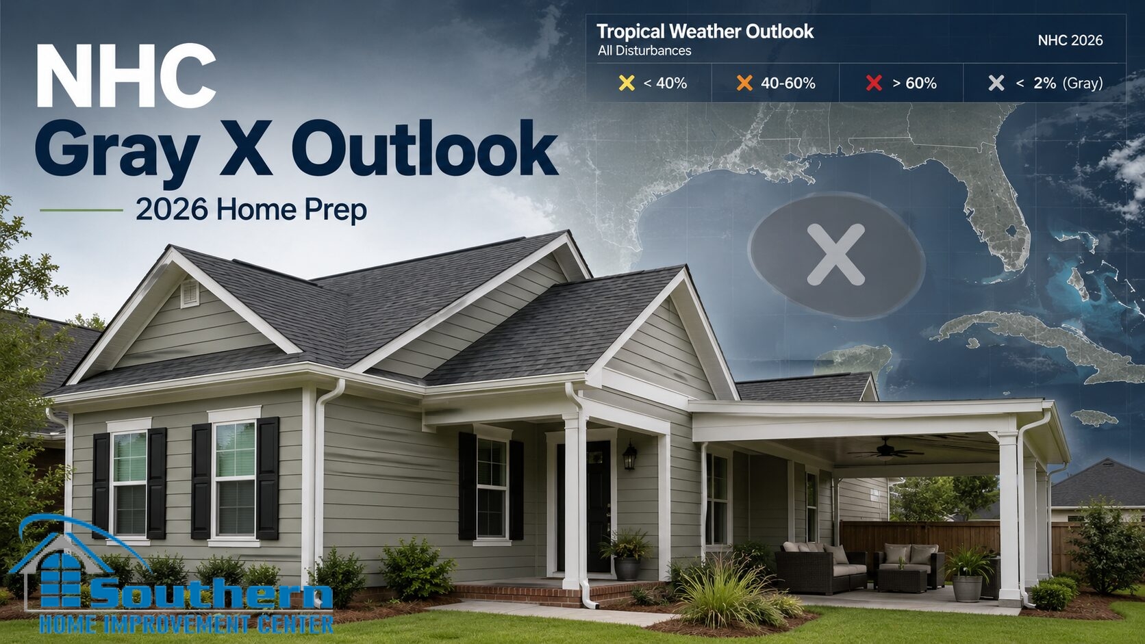
What Changed in the 2026 Tropical Weather Outlook
The National Hurricane Center updated several products for the 2026 hurricane season. One change affects the Graphical Tropical Weather Outlook: systems with a near 0% chance of tropical cyclone development in both the 2-day and 7-day outlook periods can now be marked with a gray “X.” In previous seasons, very low-chance systems were more likely to appear as a yellow “X,” which could make weak or nearly non-developing disturbances look more concerning than they were.
The purpose of the gray “X” is communication. It helps separate disturbances that are being watched but are not expected to develop from systems with a low but non-zero development chance. For homeowners, that distinction matters because not every mark on a tropical map should trigger the same level of response.
On May 18, 2026, the National Hurricane Center’s main page showed no Atlantic tropical cyclones at that time. That is a calm status, not an all-season guarantee. The useful homeowner response is to use the early outlook period to prepare while conditions are quiet.
Sources: National Hurricane Center 2026 Products and Services Update; National Hurricane Center current tropical status.
What the Gray “X” Means — and What It Does Not Mean
The gray “X” is not a warning, a watch, or a forecast cone. It is a tropical outlook symbol. It identifies a disturbance that the National Hurricane Center is noting, but where tropical cyclone development is not expected during the relevant outlook period.
That makes the gray “X” useful, but it should not be misunderstood. It does not mean “ignore hurricane season.” It does not mean “the Gulf Coast is safe for the year.” It does not mean a homeowner should wait until a map turns orange or red before checking the home’s exterior.
Gray “X”
Little to no expected development from that disturbance during the current outlook period.
Yellow / Orange / Red
Increasing levels of development potential, depending on NHC’s assessment of the system.
Homeowner action
Use calm outlook periods to inspect, repair, document, and plan before a system becomes urgent.
Why Louisiana and Mississippi Homeowners Should Still Pay Attention Early
Many homeowners only start preparing when a named storm is already on the map. That is late. By then, contractor schedules can tighten, material choices can narrow, and small exterior problems can become harder to address before rain and wind arrive.
The Tropical Weather Outlook is useful because it starts the monitoring habit before a storm has a name, a cone, or local watches and warnings. For homeowners in Southeast Louisiana, the Northshore, Baton Rouge, New Orleans, Jefferson Parish, and the Mississippi Gulf Coast, early monitoring should connect directly to exterior readiness.
That does not mean every home needs major work. It means the roof, gutters, downspouts, siding, windows, doors, patio covers, carports, screen rooms, and exterior drainage should be checked while there is still time to make practical decisions.
From Gray “X” to Yellow, Orange, or Red: When to Move Faster
The color or symbol on a tropical outlook should not be treated as the only factor in home preparation. A gray “X” can be a reminder to review the home. A yellow area can be a reason to check the forecast more frequently. Orange or red development areas should push homeowners to move faster on loose exterior items, drainage, emergency supplies, and documentation.
For a homeowner, the response should be staged:
- Quiet outlook or gray “X”: inspect roof edges, gutters, siding transitions, window trim, and attached outdoor structures.
- Yellow area: check the forecast daily, clear gutters, secure loose exterior items, and confirm drainage paths.
- Orange or red area: finish exterior cleanup, photograph the home, review insurance documents, and avoid starting non-urgent work that cannot be completed safely.
- Watches or warnings: follow official emergency guidance and focus on safety first.
Roof, Gutter, Siding, and Patio Cover Checklist Before Storm Threats Increase
This checklist is designed for homeowners who want to use the early Tropical Weather Outlook period productively. It is not a substitute for a professional inspection, but it can help identify what should be reviewed before a disturbance becomes more urgent.
| Exterior Area | What to Check | Why It Matters Before Hurricane Season |
|---|---|---|
| Roof surface | Missing shingles, lifted edges, creased shingles, exposed fasteners, granule loss, or staining after rain. | Small roof weaknesses can become water-entry points during wind-driven rain. |
| Roof edges | Drip edge condition, starter course, rake edges, eaves, fascia contact, and visible edge gaps. | Roof edges are vulnerable to wind uplift and rain pushed sideways under roof materials. |
| Flashing and penetrations | Pipe boots, vents, skylights, wall transitions, chimney flashing, and roof-to-wall areas. | Leaks during tropical rain often start at transitions and penetrations, not only in the open roof field. |
| Gutters and downspouts | Clogs, sagging, overflow stains, loose outlets, short downspout extensions, and drainage near the foundation. | Heavy rain can overwhelm weak drainage and push water into fascia, soffit, siding, or foundation areas. |
| Siding and trim | Loose panels, open seams, failed caulk, damaged trim, soft spots, and utility penetrations. | Wind-driven rain can enter behind siding through small gaps that were easy to miss in dry weather. |
| Windows and doors | Exterior caulk, sill condition, trim gaps, soft wood, water stains, and doorframe transitions. | Openings can become water-entry points when rain is pushed sideways for several hours. |
| Patio covers and carports | Loose panels, fasteners, posts, gutters, downspouts, attachment points, and movement in the structure. | Attached outdoor structures can experience uplift, drainage stress, and wind-driven rain exposure. |
| Screen rooms and enclosures | Frame connections, screen condition, roof tie-ins, door hardware, and drainage around the slab. | Outdoor enclosures need secure connections and clear drainage before tropical weather arrives. |
What to Photograph Before the First Tropical Threat
Photo documentation is one of the simplest steps homeowners can take before hurricane season becomes active. It does not prevent damage, but it creates a dated record of the home’s condition before a storm.
Take clear photos of:
- all four exterior sides of the home;
- roof slopes visible from the ground;
- gutters, downspouts, fascia, soffit, and drainage areas;
- windows, doors, siding, trim, and exterior penetrations;
- patio covers, carports, screen rooms, and attached outdoor structures;
- existing stains, cracks, soft areas, or known problem spots;
- recent repair invoices, warranty documents, and product labels.
Store those photos somewhere accessible outside the home. If damage occurs later, the record can help show what changed.
How This NHC Change Fits With Other 2026 Hurricane Updates
The gray “X” is not the only 2026 communication update homeowners may see. The National Hurricane Center also updated forecast products for the 2026 season, including changes to cone graphics and other forecast communication tools. SHIC has already covered the 2026 hurricane cone change separately, so this article focuses on the Tropical Weather Outlook and the gray “X.”
That separation matters for SEO and for homeowners. The cone is used when a tropical cyclone has a track forecast. The Tropical Weather Outlook is used earlier, when forecasters are monitoring areas of disturbed weather and development potential. Homeowners need to understand both, but they are not the same tool.
Related SHIC Hurricane Season Resources
These related SHIC pages help Louisiana and Mississippi homeowners connect the new NHC outlook symbol with roof, gutter, siding, and exterior storm-readiness planning.